|
Weather Radar |
|
 |
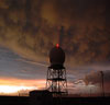
C-band (5cm
wavelength) Radar |
|
|
|
|
C-band
radar is a useful tool for the real time detection of
convective clouds, their position and their movement.
Radar has been identified as the primary tool utilized
to conduct airborne cloud seeding operations. The
basic radar displays echoes on the Plan Position
Indicator (PPI) scope, which gives a horizontal cross
section as the radar sweeps through each 360o
revolution at a fixed elevation angle. The Radar Data
Acquisition System (RDAS) is interfaced with each
radar operating in volume-scan mode. Under the control
of RDAS the radar normally will complete a series of
360o sweeps at increasing elevation angles in 3 to 5
minutes. The raw data stream is fed into RDAS where it
is processed and then exported to a TITAN Linux
workstation that runs TITAN. TITAN permits the radar
operator to examine the three-dimensional structure of
echoing clouds in real time, therefore allowing the
Project Meteorologist to vector aircraft in and around
echoing convection. Radar is also useful in estimating
rainfall because it provides rainfall data that is
equivalent of a very dense gauge network (one data
point every square kilometer). Radar estimation of
rainfall is, however, a complex undertaking involving
determination of the radar parameters, calibration of
the system, anomalous propagation of the radar beam,
ground clutter and “false rainfall”, concerns about
beam filling and attenuation, and the development of
equations relating radar reflectivity (Z) to rainfall
rate (R), where radar reflectivity is proportional to
the sixth power of the droplet diameters in the radar
beam.
|
|
|
|
NEXRAD (10cm
wavelength) radar |
|
|
Another option for the conduct of airborne cloud
seeding operaions is the WSR-88D National Weather
Service (NWS) S-band (10 cm wavelength) Next
Generation Weather Radar (NEXRAD). NEXRAD is a 10 cm
radar that does not attenuate appreciably in heavy
rain, and they are operated continuously unless they
are down for maintenance. In addition, the NEXRAD
radars have a clutter-removal algorithm that
eliminates most of the ground clutter and false
rainfall produced during periods of anomalous
propagation.
This NEXRAD data has been available since April 2004
through Weather Decision Technologies (WDT). WDT
receives instantaneous reflectivity data from the NWS
radar sites located in the United States. NEXRAD data
is run through TITAN as a graphic user interface. This
data includes a better-quality radar estimated
rainfall product making radar estimated rainfall a
much superior product in rainfall accumulation
estimation.
|
|
|
|
TITAN |
|
|
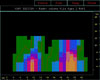
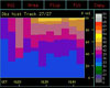
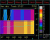
Thunderstorm Identification, Tracking, Analysis, and
Nowcasting (TITAN) software permits the radar operator
to examine the three-dimensional structure of echoing
clouds in real time. Individual echoes and groups of
echoes can be tracked and their development and motion
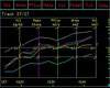
projected in time. Calculated parameters available in
real time include the radar-estimated rainfall, echo
heights, CAPPI slices, storm time-height profiles,
histories of echo volume, area, precipitation flux,
mass and vertically-integrated liquid (VIL). When
these are combined with aircraft tracking, TITAN
becomes a valuable tool for cloud seeding projects.
The ability to identify and track echoes and calculate
their properties with time makes TITAN a potential
tool for the evaluation of cloud seeding experiments.
Geostationary Positioning Satellite (GPS) latitude and
longitude data from each aircraft are collected and
viewed on TITAN. This is accomplished using the
Airborne Data Acquisition and Telemetry System (DTS).
The basic design of this system consists of a GPS
receiver within the aircraft and a radio modem
on-board. Aircraft data such as latitude, longitude,
altitude, and ground speed are transmitted to the SOAR
field office and received via a UHF antenna and
receiver. Data is then ingested in TITAN and displayed
in the active window. The radar meteorologist is then
able to vector the aircraft towards the area of
interest within the vicinity of an echoing cloud.
|
|
|
 |
|
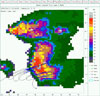
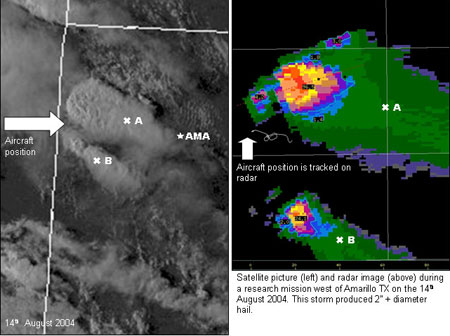
NEXRAD radar image as
viewed on TITAN 14 Aug 04 23:28Z with the
research aircraft track on the southwest flank
of the northernmost thunderstorm. |
|
|
|
|
|