 |
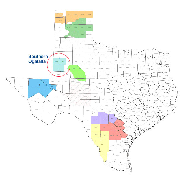
Southern Ogalalla |
|
The
Southern Ogallala program was formed in 2002 when the
Board of Directors of Sandy Land Underground Water
Conservation District, South Plains Underground Water
Conservation District, and the Llano Estacado
Underground Water Conservation District decided to
fund a weather modification program. The Texas
Department of Licensing and Regulation (TDLR) issued a
permit authorizing the SOAR program to conduct
rainfall enhancement operations in Yoakum County,
Terry County and Gaines County in Texas. Additionally,
the SOAR program has collaborated with the State of
New Mexico since the spring of 2002 in providing a
weather modification program in the plains of
southeastern New Mexico. The Interstate Stream
Commission (ISC) State of New Mexico has monitored
cloud seeding operations in parts of Roosevelt and Lea
Counties within a 90-mile radius of the SOAR field
facility in Plains, Texas. The Southern Ogallala
program covers 5.92 million acres of west Texas and
southeastern New Mexico and is referred to as the
Southern Ogallala target area. SOAR ingests NEXRAD
data from the Midland and Lubbock radars sites. These
NEXRAD sites cover the SOAR target area. The Southern
Ogallala weather modification program is a
non-randomized operational program for the primary
purpose of increasing rainfall. Hail suppression is
not an objective of the program.
|